
PROTOCOLS AND DATA SHEET
Tier 1
Tier 1
Tier 1

This is the simplest and most intuitive protocol to collect basic information on snow.
Link to the Tier 1 Sampling Protocol
Link to the Tier 1 Field Data Sheet
For more instructions, watch the Tier 1 Sampling Video in the "How To" page.
Tier 2
Tier 1
Tier 1
Tier 2 elevates Tier 1 Sampling through the collection of multiple basic snow measurements to create a transect to understand snow uniformity in an area
Link to the Tier 2 Sampling Protocols
Link to the Tier 2 Field Data Sheet
For more instructions, watch the Tier 2 Sampling Video in the "How To" page.
Tier 3
Tier 1
Tier 3
In addition to the basic snow measurements collected in Tier1 or Tier 2 Sampling, samplers collect albedo and snow water equivalent (swe) measurements and look at snowflake & snow grain size and type.
Link to Tier 3 Sampling Protocols
Link to the Tier 3 Field Data sheet
For more instructions, watch the Tier 3 Sampling Video in the "How To" page.
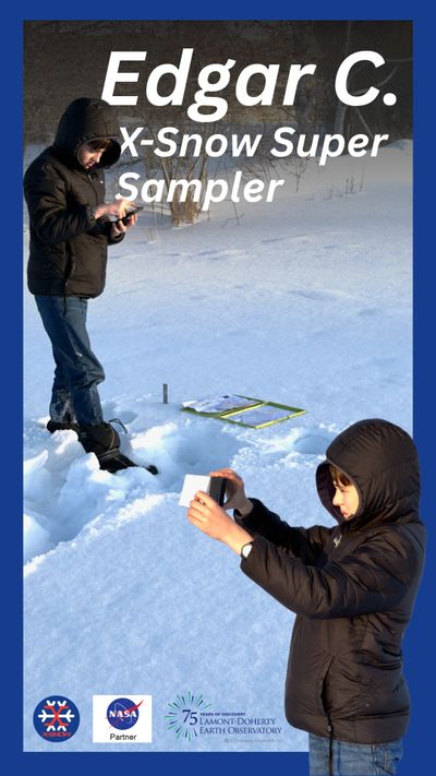
Meet Edgar, our X-Snow Super Sampler!
At just 12 years old, Edgar has already become a key contributor to X-Snow, providing vital data throughout the winter! Edgar has collected 17 samples this summer, ranging from 11 to 34 cm. To go beyond the numbers, we asked Edgar a few questions about how he got involved in X-Snow and to learn a little more about him:
How did you learn about X-Snow and what made you interested in participating?
"I learned about the X-Snow project during a meeting at the Schoharie River Center. I was interested in participating because I thought it was really cool to learn how NASA collects snow data and why it is important."
Is this your first citizen science project, or are you involved in others?
"I already participated in a science program at the Schoharie River Center, where I collected water quality data during the summer."
What is your favorite part about sampling and why?
"My favorite part is going outside, taking pictures, looking closely at snowflakes, and collecting data."
How has participating in X-Snow changed how you think about snow or the environment?
"Participating in X-Snow changed the way I think about snow. Before, when I looked at snow, I just saw frozen water. Now I think about how snow is white and reflects sunlight instead of absorbing it like dirt or grass, and how that can affect the temperature of the Earth."
What questions about snow science are you still curious about?
"I still have questions about how snowflakes form and how their shape depends on the temperature."
What are your favorite snow activities?
"My favorite snow activities are downhill skiing and cross-country skiing!"
Thank you Edgar, for your dedication to sampling and helping contribute to X-Snow citizen science!
USEFUL LINKS AND PARTNERS
MESONET snow stations
Community Collaborative Rain, Hail and Snow Network (COCORAHS)
MOUNTAIN RAIN OR SNOW (NASA CitSci Project!)

The New York State Mesonet operates a sub-network of snowpack monitoring stations across select areas of the Adirondacks, Tug Hill, and Catskills. These "Snow" stations specifically measure snow depth and Snow Water Equivalent (SWE). Snow depth is measured every 5 minutes, and SWE is estimated over a 6-hour period with observations provided up to four times daily..
MOUNTAIN RAIN OR SNOW (NASA CitSci Project!)
Community Collaborative Rain, Hail and Snow Network (COCORAHS)
MOUNTAIN RAIN OR SNOW (NASA CitSci Project!)
Mountain Rain or Snow asks you to tell them about rain and snow near you to support better weather and water resources forecasting. Your reports of precipitation type sent through the project’s smartphone browser tool will help scientists understand where current technology falls short.
Community Collaborative Rain, Hail and Snow Network (COCORAHS)
Community Collaborative Rain, Hail and Snow Network (COCORAHS)
Community Collaborative Rain, Hail and Snow Network (COCORAHS)
The Community Collaborative Rain, Hail and Snow Network, or CoCoRaHS, is a network of volunteer weather observers in the United States, Canada, and the Bahamas that take daily readings of precipitation and report them to a central data store over the Internet. The program is an example of citizen science.